About Kennebecasis Island
Kennebecasis Island only started to be inhabitated in the latter part of 18th century due to the arrival at Saint John harbour of United Empire Loyalists fleeing the outcome of the American War of Independance. The 'spring fleet' of Loyalists from New York arrived at Saint John in May of 1783 and were quickly granted land for resettlement.
Although First Nations peoples (primarily the Maliseet and Mi'kmag) paddled the St. John and Kennebecasis Rivers extensively to forage and trade, it does not seem that they had used the Island at all. With the arrival of Europeans in North America the local Natives would travel to and from the harbour at the mouth of the St. John River (where the river emptied into the Bay of Fundy) to trade with New Englanders who visited seasonally. Again, and having to pass Kennebecasis Island on this trade route, there is no indication that the Island was a place of interest or convenience for the Natives.
Kennebecasis Island Crown land grants were first written in 1785. Prior to that there were no inhabitants on the Island - Native Peoples or Europeans.
Kennebecasis Island
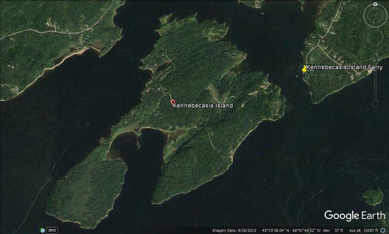
Kennebecasis Island (below pic) showing McCormick Cove looking out into Grand Bay - St. John River in the upper right corner, the Kennebecasis River in the lower left corner
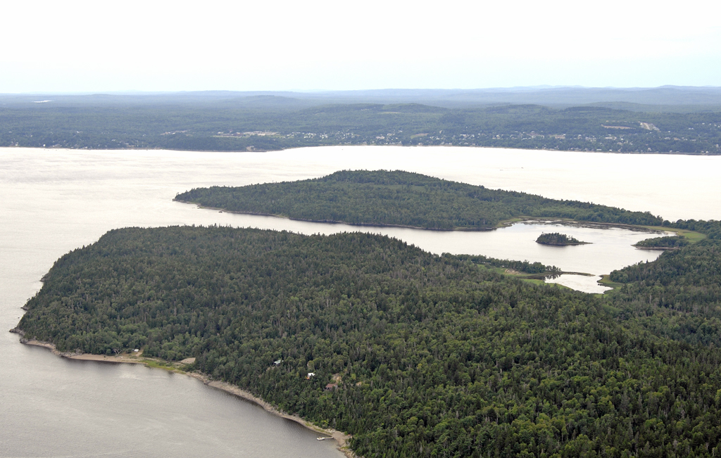
Kennebecasis Island - As it Began
Introduction
Kennebecasis Island is located at the southwest end of the Kingston Peninsula in Kings County, New Brunswick and is within the Parish of Westfield. It is bounded to the west by the St. John River and to the south by the Kennebecasis River (sometimes called, Kennebecasis Bay). To the east and north, the Island is separated from the Kingston Peninsula and the nearby communities of Bayswater and Summerville, by a narrow channel of water, variously called “Milkish Bay”, “Milkish Cove”, “Milkish Channel” or “Milkish Creek”. The town of Grand Bay-Westfield is opposite the Island on the western side of the St. John River while the Millidgeville area of Saint John’s North End is directly across the Kennebecasis River. The Island comprises about 1100 acres and is heavily forested except for those areas where farms were established in the mid to late 1800s.
Earliest Crown grants
Thirteen (13) lots were laid out on Kennebecasis Island as a result of a survey carried out in the late 1700s. Lot 1 was on the end of the peninsula of land on the west side of what has since become known as McCormick Cove. The remainder of the lots were laid out proceeding clock-wise around the Island with lots 12 and 13 on the east side of McCormick Cove (see figure 1).
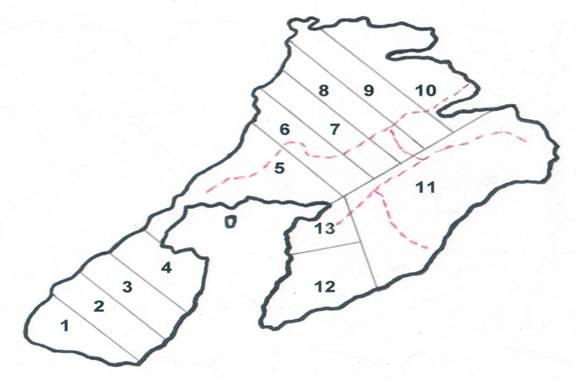
Figure 1
Lots on Kennebecasis Island following a survey in the late 1700s. Grey lines represent lot boundaries while the dashed lines are roads. The line separating lot 11 from lots 12 and 13 runs north-south by the compass. The inlet on the south side of the Island is McCormick Cove. Ownership of lots 1-10 passed from the Crown to 10 grantees (most likely United Empire Loyalists) through a land grant dated October 13, 1785 (grant no. 10). The grantees (beginning with lot 1) were: Josiah Stone, John Watson, Robert Hustice, Lewis Frazee, Michael Butler, Joseph Wood, John Bough, Bernard Mullen, Jeremiah Mabee and Gilbert Merritt.
John Foster was granted lot 11 (the largest of the Island lots at 300 acres) on March 18, 1835 (grant no. 347). Lot 13 (30 acres) was granted to John McCormick on December 18, 1837 (grant no. 1383) while lot 12 (50 acres) was granted to Ralph McCormick on April 9, 1843 (grant no. 3017).
Other than the McCormicks, none of the original grantees, or their families, settled on the Island.
First families
The first non-native known to inhabit the Island year-round was James Keefe, a Loyalist who arrived in Saint John with his family in 1783. In 1789, he purchased land on the Island and in 1807, successfully petitioned the Crown for additional acreage. In the petition, he stated that he had been living on the Island for 12 years and that his was the only family there. By the mid 1830s, the Charlton, McCormick, and Johnston families, among others, had joined the Keefes on the Island. When the first New Brunswick census was taken in 1851, there were about 80 people calling Kennebecasis Island home. However, the Island’s permanent population did not grow thereafter. Although other families (e.g., Irvine, Adams, Morrow and Hutchings) came to live on the Island, many of the adult children of the original families left for Saint John or nearly New England. By 1891, the Island had fewer than 50 permanent residents and by the late 1940s, no one was living there year-round.
Kennebecasis Islanders farmed the land, fished the Island’s waters and sold timber to the nearby saw mills. The Island’s biggest cash crop was hay and there was a ready market for this in nearby Saint John. Other cash crops included potatoes, carrots, turnips, beets and apples. Horses, cows, pigs, hens and sheep were common to most farms and provided Islanders with milk (and cream and butter), meat, eggs and wool for making clothing. Islanders were close-knit and helped each other as needed. Property taxes were paid through road work - cutting bushes, and repairing and leveling public roadways. Families took turns hosting their neighbours - dances were common and skating parties were held in winter.
Travel to Saint John in the non-winter months was via boat. In the 1800s and early 1900s, riverboats made their way up and down the St. John and Kennebecasis Rivers, departing from Indiantown in the North End of Saint John. Steamers travelled up the Kennebecasis as far as Hampton and made stops on the Kingston Peninsula as well as the south shore of Kennebecasis Island at the end of McCormick Road. In the winter, Islanders went to and from Saint John via horse-drawn sleigh, on skates, or by foot across the frozen Kennebecasis River.
Ferry service
In 1880, seasonal ferry service was established between Millidgeville, the Kingston Peninsula (Summerville and Bayswater), and the Island. The first ferry was the privately-owned toll ferry “Enterprise”, a paddlewheel steamer which made 4 trips daily. The “Enterprise” was followed by the side-wheel steamer “Maggie Miller”, also privately owned, which began operating in 1892. The “Maggie Miller” made 3-5 trips/day (depending on the day of the week) between May and November, transporting people as well as horse-drawn carts and carriages and later cars and trucks. In the early 1900s, a bus service connected Millidgeville with the street car line at the corner of Adelaide and Main streets in Saint John making it convenient to get to and from the ferry. The “Maggie Miller” was replaced in 1934 by the “Maggie Miller II”, another side-wheeler but with a diesel engine. The second “Maggie Miller” was in service until 1955. The “D.L. MacLaren” served on the Kennebecasis River between 1956 and 1967 and it was followed by the “Romeo and Juliette” which operated for 34 years from 1968 until 2001. By the late 1940s, the New Brunswick government had taken over operation of many of the province’s river ferries, including the “Maggie Miller II”, and the ferries became toll-free. Seasonal ferry service to Kennebecasis Island has continued to present day. Since 1968 this service has been provided by a dedicated ferry that operates across the Milkish Channel between the Island and Summerville.
A post office
In early 1894, Islanders applied to the Federal Government for a post office. At the time, there were post offices in Millidgeville and Bayswater and mail could be delivered to and from the Island via the ferryboat “Maggie Miller”, at least from May until November when the ferry was operating. The application was approved in November 1896 and the Island post office opened in September 1897. The first postmaster was George Johnston who was appointed on September 1, 1897 and carried out his postal duties until his resignation on December 1, 1899. James M. Keith was postmaster from February 1, 1900 until his death in September 1912. Keith’s son, Louis became postmaster on October 15, 1912 and held this position until the office closed on September 30, 1937. Johnston and the Keiths provided postal service (e.g., stamp sales, and letter and parcel drop-off and pick-up) from their farmhouses.
An April 1894 Post Office Inspector’s report, accompanying the application to establish a post office on Kennebecasis Island, states that there were 12 permanent resident families on the Island. By the 1930s, the Island had only 2 families (Keith and Hutchings) living there year-round and only the postmaster’s family (Keith) was using the post office. Consequently, in 1936 local postal authorities recommended closing the Island office and on September 30, 1937 it closed. Efforts were made in 1950 to reopen the post office on a seasonal basis from June 1 until September 30. However, the Post Office Department deemed this to be unjustified due to the fact that there were no permanent residents on the Island.
The Johnston “hotel”
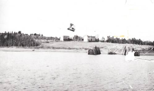
The Island’s only “hotel” opened in the summer of 1894. It’s referred to in the Post Office Inspector’s report from April 1894 where a postal employee wrote “a summer hotel just completed will be opened during the coming season, but it is very uncertain as to what extent it will be patronized.” The “hotel” was built and operated by the Johnston family who took advantage of their proximity to where the ferry “Maggie Miller” docked. The “hotel” was not a hotel in the traditional sense where guests would stay for a few days or maybe a week. For the most part, it was occupied by two or three families for the whole of any given summer. It was therefore more like a cottage than a hotel. The “hotel” was still being used during the summer months as late as the mid-1970s. However, by this time, it had deteriorated somewhat and only part of the building could be lived in. The “hotel” was demolished in the late 1970s when the property was owned by the Ferris family.
Johnston Hotel
hotel in foreground with ferry dock at water's edge
Schools
In a publication entitled “Early Schools of Kings County, published in 1985 by the Kings County Retired Teachers Association, Julia Walker has written that as early as 1840, schooling was available to the children on Kennebecasis Island. Thomas Crawford was the Island teacher from 1840 until the late 1850s. According to provincial school records, Crawford had 24 students in 1842, 21 in 1845 and 28 in 1850. The students (both boys and girls) ranged in age from 5-17. All of the Island families with children were represented in Crawford’s classroom. In August 1844, a school inspector reported that Crawford was 36 years old and married, and that he had a teaching license dated August 6, 1832. Crawford was described as “a good reader and writer” who “had a competent knowledge of arithmetic but not of English grammar.” The school was described as 20x14x7 feet with convenient seats but poor desks, old and out of repair, and public property provided by the people. “Public property provided by the people” refers to the fact that the school was built by the Islanders, not the Government, and open to all of their children. More than half of Crawford’s salary came from voluntary contributions from the Islanders. The inspector’s report also noted that the children’s parents supplied the school books (Wilkingame and Gough’s Arithmetic, Manson’s Primer, Dilworth and Finnegan’s Spelling Book and Elements of History) and that “the people of the Island are said to be very poor, the attendance is irregular and the school is in a backward condition.”
Thomas Crawford owned land on the Island between 1839 and 1864. However, he left the Island sometime before 1861 since in the census of that year, he is listed as living in Hammond, New Brunswick, a short distance east of Saint John.
In 1857, George Irvine purchased property on the Island, built a farm house, and lived there until his death in 1866. He was a retired school teacher who had taught for many years at the school in Milkish, across the channel from Kennebecasis Island. Irvine followed Crawford as the Island school teacher. Children attended classes at Irvine’s farmhouse where he had a room off the dining room with a long table and small chairs that he used as his classroom. Given that the school where Crawford taught was described in 1844 as “out of repair” and “in a backward condition”, it’s likely that this building was no longer useable when Irvine began teaching. It’s not known who followed George Irvine, if anyone, in the late 1860s as the Island’s schoolmaster.
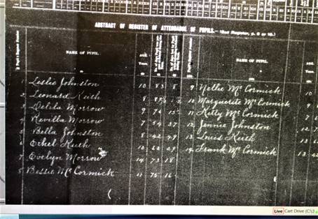
In 1871, the Legislative Assembly of New Brunswick passed the Common Schools Act for the development of a public school system to provide education, free of charge, to all New Brunswick children. New school districts were established and new schools built. Consequently, in February 1875, the Westfield Parish School Board purchased land from Catherine Johnston on “Old Ferry Road”, constructed a one-room school house and provided a teacher, all with public money. Kennebecasis Island became school district 9 within the parish. The school was open by at least January 1877 and closed in December 1906. School records show that children aged 5-16 attended classes on “Old Ferry Road”. The number of students in any given year varied from about 10 to about 20. In the fall of 1906, the last semester that the school was open, there were only 9 students. Most of the teachers stayed with families on the Island rather than commuting from Saint John or the nearby Kingston Peninsula. The teachers during the school’s last years included Nellie Hoyt (1899-1904), Nina Gregory (1905), Leslie Kennedy (1906) and Margaret Beatrice Gillen (1906). Beginning in 1907, Island children went to school in Bayswater or Millidgeville.
Kennebecasis Island School Register 1903
Cemeteries
There are two cemeteries, both private, on Kennebecasis Island - the Keith family cemetery and the Hutchings family cemetery.
The Keith cemetery is on land still owned by members of the Keith family. Mary Keith, who died on February 10, 1943, was the last burial there. The Keith family estimates that there are 38 graves in their cemetery but an exact number cannot be determined since records have been lost for many burials and most of the grave markers (wooden) have been removed and/or destroyed. Keiths buried there include William (d. November 21,1901, age 84) and his wife Elizabeth (d. May 18, 1904, age 85), their son, James M. (d. September 16, 1912, age 60) and James’ two wives, Elizabeth (d. 1879, age 23) and Mary (d. February 10, 1943, age 85), and James and Elizabeth’s infant baby (d. 1879). In addition to the Keiths, members of the Flemming, Morrow and Woods families are interred in the cemetery.
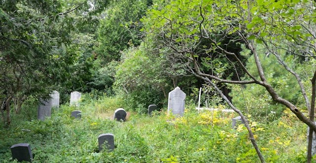
The Hutchings cemetery, also known as the Loyalist cemetery, is on land originally owned by William Charlton and later by his daughter, Sarah Hutchings. As with the Keith cemetery, wooden markers have been destroyed. However, there are a number of stone markers that are still in reasonably good condition. It’s not known how many burials were made in the Hutchings cemetery but the last interment occurred in April 1932 (Sarah Irvine, a granddaughter of William Charlton). Kennebecasis Island residents buried in the cemetery (pictured below) include:
1. William Charlton c1800 - Dec 21, 1886
2. Sarah Charlton (née Donald, William’s wife)c1796 - Sep 29, 1874
3. Robert Strayhorn c1811 - July 29, 1877
4. Isabella Strayhorn (née Charlton, William’s daughter) c1825 - February 1, 1902
5. John Hutchings Sr 1835 - 1914
6. Sarah Hutchings (née Charlton, William’s daughter) 1840 - 1923
7. James H. Carter c1821 - December 18, 1896
8. Catherine Carter c1827 - May 18, 1911
(née Charlton, daughter of William and widow of Thomas Johnston and James Carter)
9. Arthur G. Irvine 1846 - 1913
10. Sarah J. Irvine 1845 - 1932
(née Johnston and granddaughter of William and Sarah Charlton)
11. William L. Saunders c1815 - June 23, 1879
12. Elizabeth Saunders (née Christie) d. 1879
13. Thomas and Walter Irvine - young sons of Arthur and Sarah Irvine
